
Krakow Old Town map: district and sight orientation
Use this Krakow Old Town map to locate the square, gates, Wawel and station. Read the original diagram, numbered places and practical route cautions.
Old Town district orientation
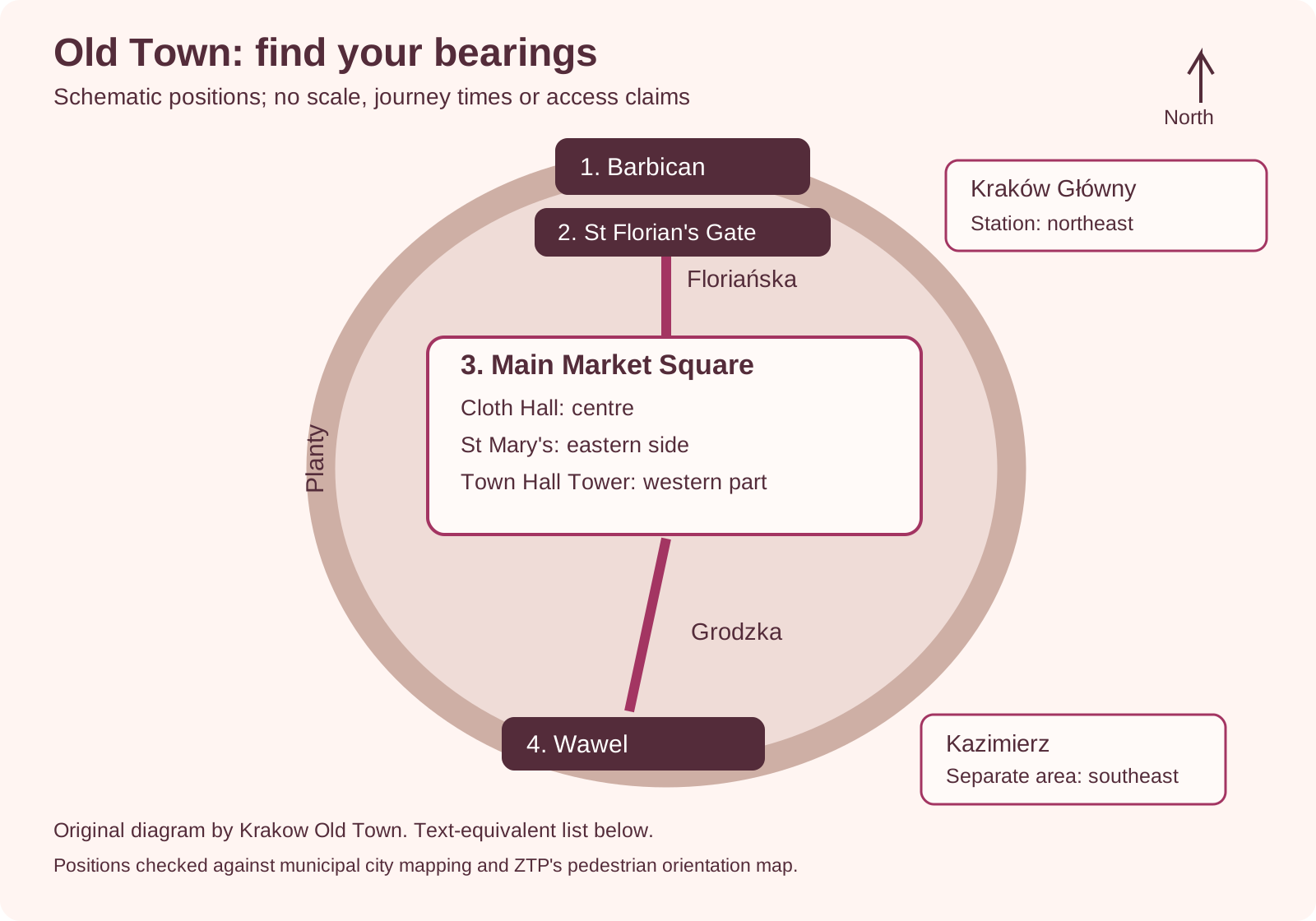
Planty surrounds the medieval core. The Barbican and St Florian’s Gate are north of the square; Wawel is south. Kraków Główny is northeast of the core and Kazimierz farther southeast. The square holds the central Cloth Hall, eastern St Mary’s and western Town Hall Tower.
Map with a full text route below
Reference: Schematic
- Meaning
- No scale, journey time or step-free guarantee
Reference: District use
- Meaning
- Find the square, Planty, Wawel and the station relative to each other
Main square and sights
The central Cloth Hall, eastern St Mary’s and western Town Hall Tower help identify the square. Their visitor entrances remain separate decisions.
Choices with every field
Map label: Main Market Square
- What it helps you locate
- The central public space
- Detail to save separately
- Your meeting place on a particular side
Map label: Cloth Hall
- What it helps you locate
- The trading building in the square
- Detail to save separately
- The gallery entrance if visiting MNK Sukiennice
Map label: St Mary's
- What it helps you locate
- The church beside the square
- Detail to save separately
- The sightseeing or tower instructions
Map label: Town Hall Tower
- What it helps you locate
- The separate tower landmark
- Detail to save separately
- Museum entry information
Map label: Wawel
- What it helps you locate
- The hill and its visitor choices
- Detail to save separately
- The exact castle exhibition or cathedral reporting point
Museum of Krakow's branch information; PKP's passenger information; Krakow transport authority ·
A Krakow Old Town map is most useful when it separates the central streets from the station, Wawel and other districts. Use the Main Market Square as the central reference point. The gate area is north of it, Wawel lies to the south, and Kraków Główny station is northeast of the old centre. Kazimierz is another area to plan, rather than an extra street beside the square.
The original diagram above shows those relationships. It is a schematic, not a navigation map or a measured route. Use it to understand the shape of a visit, then use current city mapping and signs for the actual journey. No line in the drawing promises a step-free path or an open attraction entrance.
Find the square first, then identify the direction of your next stop. Floriańska connects the northern gate area with the square; Grodzka leads south towards Wawel. Planty marks a useful edge around the old centre. Save the exact visitor entrance for any timed booking and keep station exits distinct from sightseeing stops.
Krakow Old Town map: read the district diagram
Read the diagram as an orientation aid with deliberately simplified positions. Its numbered places help you organise a walk. They do not assign a duration or distance to it. The station and Kazimierz are shown to explain their relation to the centre, without suggesting that the drawn gaps represent real journey lengths.
The text equivalent is:
- The Barbican is in the northern gate area.
- St Florian's Gate lies between that area and the central streets; Floriańska leads toward the square.
- The Main Market Square is the central reference. The Cloth Hall is central, St Mary's is on the eastern side and Town Hall Tower in the western part.
- Grodzka leads south toward Wawel, where cathedral and castle visits are distinct.
- Planty surrounds much of the old core and helps identify its edge.
- Kraków Główny station lies northeast of the central square.
- Kazimierz is farther southeast and needs its own route decision.
Keep a full street map available alongside this simplified view. The diagram omits many streets and crossings so the key relationships remain legible. An omitted street may be the one you need for your lodging or an accessible approach. Use the full address when you search for a destination.
Boundary and entrances
Use Planty as an orientation edge, while keeping formal district boundaries distinct. A sightseeing phrase such as “Old Town” can describe a smaller area than an administrative district or the whole UNESCO heritage property. This page is about finding the old centre and its main landmarks, not defining a legal planning boundary.
At the northern gate area, identify the Barbican and St Florian's Gate as different structures. They can appear close together on a small map. Their entrance arrangements are not one generic “gate ticket”. If you want an interior visit, open the Museum of Krakow's branch information and check the named route.
You can also enter the central streets from other sides of Planty. There is no need to begin every walk at the northern gate. Choose a starting point that fits where you are staying or getting there. The route becomes simpler when your first landmark is one you can readily find from that location.
Do not mistake a drawn boundary for a barrier. A park edge is a reference, not a statement that every crossing is easy or that traffic conditions are the same everywhere. Check the street-level route before crossing, particularly with children, luggage or mobility needs.
Distinguish the buildings around the square before searching for an entrance. The Cloth Hall's stalls and upstairs gallery serve different visits. Rynek Underground has its own visitor approach. St Mary's church sightseeing and tower entry also have distinct arrangements. A single square pin cannot describe all those doors.
When meeting someone, name a precise place rather than simply “the square”. Agree which building or entrance you mean and which side you will wait on. A shared screenshot with a marked point can help, provided everyone can read it and has the same plan.
If you are visiting two interiors, save two sets of instructions. An address may identify the building without settling the public entrance. Read the confirmation attached to each ticket and compare it with signs on arrival. The map tells you where to head. The operator tells you where to report.
For a wider picture of the visits themselves, return to the Krakow Old Town guide. Use this page for orientation rather than choosing a museum solely because its pin lies near your next stop. The subject and entry conditions still matter.
Station and arrival connections
Treat Kraków Główny as an arrival system with several connections, not a single doorway facing Old Town. PKP's passenger information gives the station address as Pawia 5a and describes access through the surrounding complex. Check the way out that serves your actual destination.
Before leaving the train, have your lodging's full address ready. You may want to drop luggage before walking towards the square. A hotel described as “Old Town” can still require a different approach from the one shown in a sightseeing diagram. Its own check-in instructions can help identify the entrance and any vehicle drop-off limits.
If you use a tram or bus after arrival, consult the Krakow transport authority for the current service. The older ZTP pedestrian map used as a geometry source here does not establish today's transport timetable or access conditions. Keep that difference clear when reading any saved map.
For a taxi or arranged pickup, use the agreed meeting point. Do not assume that a driver can collect you at the platform or at whichever exit you happen to choose. Read the booking instructions before leaving the station complex and contact the provider if the point is unclear.
Accessible-route cautions
The schematic cannot certify a route for a wheelchair, pushchair or anyone avoiding steps. It does not show gradients, surface changes, temporary works or the condition of lifts. Those details need evidence for the actual journey, including the starting point and the entrance you must use.
If step-free access is vital, ask two distinct questions. First, check whether your route reaches the building. Then check access to its entrance and display areas. A museum's lift does not answer the street journey, and a smooth street approach does not promise access inside.
At the station, use PKP's accessibility information for the assistance and facilities it describes. Confirm arrangements for your journey rather than assuming an icon means every transfer will work without help. Allow time to follow the route staff recommend.
For walking stamina, reduce the number of areas rather than relying on the short gaps in a schematic. You can focus on the square and one nearby interior, then leave Wawel or Kazimierz to another session. That plan can be useful without claiming a measured accessible circuit.
Choose a numbered walk
Use the numbered places to choose a direction, then move to a route guide for the execution. A north-to-south option starts around the Barbican and gate, continues through Floriańska to the square, then heads towards Wawel. The reverse direction may fit better if you are already near Wawel or staying south of the market.
You do not have to complete the whole sequence. Stop at the square if that is enough for the day, or insert your chosen museum appointment there. Leave room for meals and any wait at an entrance. The orientation order is not a schedule that requires you to keep moving.
The walking tour map turns the central sequence into a more detailed self-guided choice. Use that page for stop order and route decisions. This diagram remains a district overview, with fewer details and no journey estimate.
Schindler's Factory is at Lipowa 4 beyond this central view. The factory visit guide covers the museum booking and arrival preparation. Do not add it to the bottom of an Old Town diagram and treat the journey as solved. It needs a real route from your starting point.
For travel outside Krakow, use the day-trip comparison. An excursion's pickup point might be near the centre. The visit is not part of this street circuit. Save the exact pickup instructions alongside the museum or attraction booking.
Map sources and corrections
- Municipal city map: landmark and street relationships, viewed as a PDF in October 2026.
- ZTP pedestrian orientation map: published map used for broad geometry only, not current times or facilities.
- PKP Kraków Główny passenger information: station identity and arrival context.
- Krakow transport authority: current transport information.
The diagram is newly drawn for this guide. It does not copy the official maps' artwork or symbols. If you spot a location error, include the named place and a current authority source when contacting us. Temporary changes need a dated report, since this drawing does not track live street conditions.
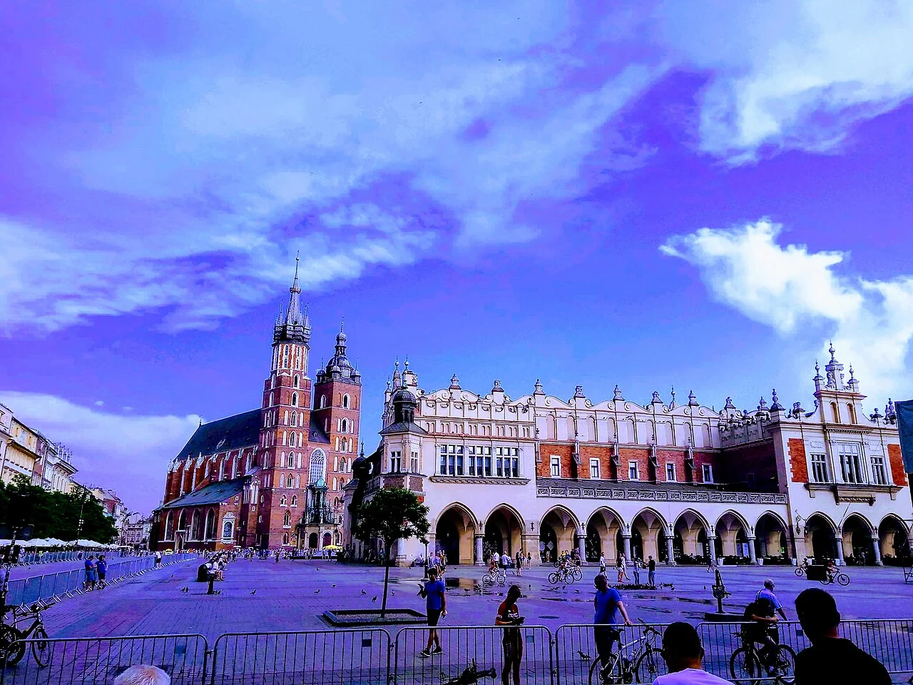
Photograph: Rynek Glowny Krakow.jpg by Nithin C, CC BY-SA 4.0. Resized and converted to WebP; no crop.

FAQ
Is this map accurate enough for turn-by-turn navigation?
It shows broad relationships only. Use a current street map and signs for the precise route.
Is Kraków Główny inside the market square area?
The station is northeast of the square. Choose the exit and onward route for your actual destination.
Does the map include all of the UNESCO property?
No. It focuses on central orientation and shows Kazimierz only as a distinct area beyond the core view.
Verdict on the Krakow Old Town map
Use the Krakow Old Town map to understand the centre's shape, from the northern gate to Wawel. Then save the exact address and entrance for each booked visit. The original schematic makes the relationships clear. A current street map handles the route details it intentionally leaves out.